CLIMATE:
What Effect Does Geography Have on Climate?
http://science.opposingviews.com/effect-geography-climate-5100.html
by John Peterson, Demand Media
Geography and climate are interrelated.
Ablestock.com/AbleStock.com/Getty Images
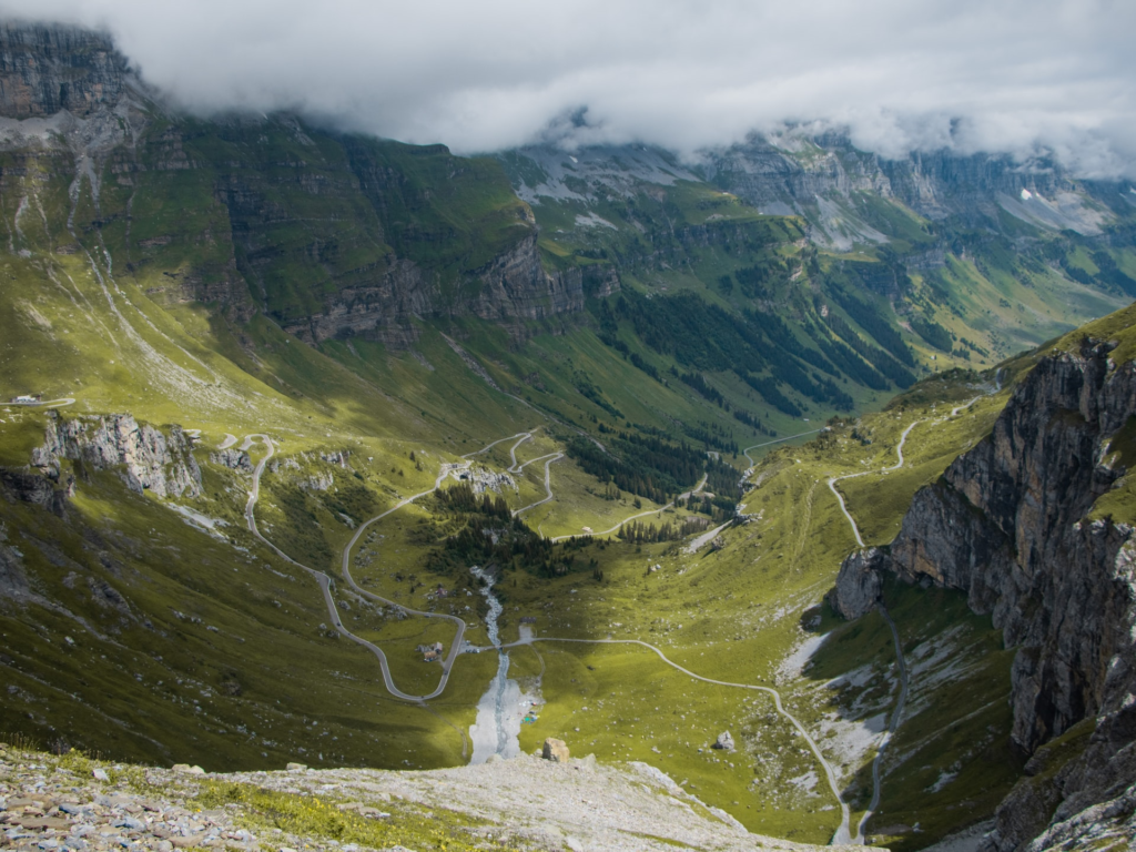
Geography has a primary effect on climate, and a good idea can be formed about the particular climate of a given area by its location on a map. The mountains, valleys and bodies of water in local topography influence precipitation and temperature. The distance north or south from the equator also greatly affects temperature and can impact precipitation. In addition, being near or far from a coastline influences climate.
Latitude
Because the rays of the sun are more direct at the equator, the warmest temperatures as seen on a broad scale are found in equatorial regions. Tropical areas are warm climates found within 23.5 degrees north or south of the equator. Temperate zones with warm summers and cool to cold winters are found between 23.5 and 66.5 degrees north or south. The cold arctic regions are found north or south of 66.5 degrees latitude. Precipitation can vary greatly, however, within the latitude boundaries due to topography, elevation and ocean currents.
Elevation
Temperatures tend to be cooler at higher elevations, roughly 1 degree Celsius for every 100 meters of altitude. Daily high and low temperatures will also vary more widely at higher elevations. Mountains produce orographic precipitation, which heavily influences local climate. Air cools at is ascends the windward side of a mountain, but cool air cannot hold as much moisture as warm air. Thus, as the air moves up the mountain and cools, it becomes saturated and releases its moisture as precipitation. At high elevations, it often freezes, and precipitation consists of snow and ice. When air descends along the leeward side of a mountain, however, it warms and holds its moisture, creating dry conditions.
Local Topography
As seen, mountains greatly affect local climate, and valleys can likewise produce a profound effect on local climate. For example, the hottest and driest area in the United States is Death Valley, California. Death Valley is dry due to the warming of air descending the leeward side of the Sierra Nevada mountains. It becomes especially warm as the warm air settles in Death Valley 86 meters (282 feet) below sea level. Local topography near large bodies of water can also affect climate as air can pick up humidity from the water, and the water also influences the temperature of air currents.
Oceans
The temperature of ocean currents will affect climate along coastlines and inland. The wind will carry warm air off of warm ocean currents and increase temperatures along coastal areas. When this warm ocean current air meets cool air on land, it can also create greater precipitation. Seasonal changes affect oceans more slowly than land. Thus oceans heat up more slowly in the summer and produce cooler summer temperatures. Likewise, they cool more slowly in the winter and produce warmer temperatures than land.
FARMING:
Topography and Soil, Abiotic Factors Affecting Plant
http://www.cropsreview.com/abiotic-factors.html
Growth, Development and Distribution
The abiotic factors that affect plant growth and development include topography, soil, and climatic factors. They are the nonliving components of the environment which, along with the biotic or living factors, determine the extent in which the genetic factor is expressed in the plant.
Topography
Topography is a nonliving factor that refers to the “lay of the land.” It includes the physical features of the earth such as the land elevation, slope, terrain (flat, rolling, hilly, etc.), mountain ranges and bodies of water.
The slope or inclination of a land is the percentage change in its elevation over a certain distance. It is measured by dividing the vertical distance from the foot to the top of the land by the horizontal distance between those points, multiplied by 100. A 45-degree angle of elevation is equivalent to 100% slope.
The steepness of a slope affects plant growth through differential incidence of solar radiation, wind velocity and soil type. A steep slope is susceptible of rapid surface runoff and soil erosion which cause soil degradation.
It is known that where a landscape serves as a barrier against the movement of pollen or seed between two plant populations, the populations will begin to differ either through mutation or genetic drift. However, depending on the plant species and their modes of dispersal, habitat fragmentation and their separation by distance may not always become effective barriers. Researchers recently found that hummingbirds seem to be more effective than bees in transferring pollen of Penstemon from one mountain range to another across large distances (American Journal of Botany 2011).
The altitude or elevation of the land with respect to the level of the sea surface influences plant growth and development primarily through temperature effect. The relationship of this abiotic factor to temperature is like that of distance from the equator to the arctic poles. According to Stiling (1999), temperature decreases by 1 C for every 100 m increase in altitude in dry air.
This abiotic factor is an important consideration in crop or site selection for more productive crop farming. Coconut prefers an elevation not exceeding 600 meters above sea level (masl) (PCARRD 1982); for better quality, tea is best grown above 1000 masl while rubber requires not more than 500 masl because at higher elevation latex flow is restricted (Abellanosa and Pava 1987); the seasonality of ripening of various fruit crops, e.g. durian , is modified when they are planted in different elevations.
The effect of land elevation on plant growth and development is apparent when exploring a high-rise mountain. Dominance of certain plant types varies with elevation. With change in height from sea level to 16,000 feet (4,876.8 meters) from the foot to the top of a mountain in the Peruvian Andes or New Guinea, temperatures change from tropical to subtropical, temperate, and subarctic to arctic.
Likewise, the influence of this abiotic factor on plant growth and distribution is noticeable. There is a change from tropical vegetation at the coastal base to the oak forest, then conifers, and finally a tundra-like scene with hardy grasses, mosses and dwarf shrubs. At the arctic top, only occasional lichens are found on exposed rocks.
In the tropics, the timber line above which no more tree grows may be found between 13,000 to 14,000 feet above sea level or 3,962-4,267 masl (Went and The Editors of Life 1963).
SOIL FORMATION
Topographic Factors In Soil Formation
http://www.kidsgeo.com/geology-for-kids/0006-topographic-factors-in-soil-formation.php
The up and down changes in hills and mountains of a particular location is referred to by scientists as topography. Topography has an important influence in how soils form.
The first topographic factor is steepness of hill and mountain slopes. All soils around the Earth are slowly getting deeper and deeper, as lower levels of dirt are being turned into soil. At the same time, wind and water carry the surface soil away through erosion.
In areas which are flat, the soil typically tends to get deeper quicker than the surface erodes away. On steep slopes, erosion usually takes place quicker than the formation of new soil beneath.
The result is that flat locations typically have a deeper, more mature soil layer than do locations with a steep slope.
The second topographic factor affecting soil formation is drainage, or in other words, how well the soil is able to get rid of extra water via draining it. Most locations have excellent drainage, but some locations do not. Some locations become water logged. This water blocks oxygen, which is important to soil formation. Thus in these locations soil formation can become seriously hindered.
WEATHER
Why do mountains affect weather and climate?
http://www.weatherwizkids.com/weather-climate.htm
There are two sides to a mountain: wayward and leeward. Whenever it is raining, the wayward side gets the rain. As a cloud goes up the mountain, it keeps raining until there is no more water in the cloud. Now, as the cloud starts to go down the other side of the mountain, there is no more precipitation. So, the leeward side of the mountain doesn’t get any rain. The flat ground on this side of the mountain is dry and humid.
SOIL FORMATION
Factors Affecting Soil Development
Topography has a significant impact on soil formation as it determines runoff of water, and its orientation affects microclimate which in turn affects vegetation. For soil to form, the parent material needs to lie relatively undisturbed so soil horizon processes can proceed. Water moving across the surface strips parent material away impeding soil development. Water erosion is more effective on steeper, unvegetated slopes.
AGRICULTURE
http://www.cropsreview.com/abiotic-factors.html
Topography is a nonliving factor that refers to the “lay of the land.” It includes the physical features of the earth such as the land elevation, slope, terrain (flat, rolling, hilly, etc.), mountain ranges and bodies of water.
The slope or inclination of a land is the percentage change in its elevation over a certain distance. It is measured by dividing the vertical distance from the foot to the top of the land by the horizontal distance between those points, multiplied by 100. A 45-degree angle of elevation is equivalent to 100% slope.
The steepness of a slope affects plant growth through differential incidence of solar radiation, wind velocity and soil type. A steep slope is susceptible of rapid surface runoff and soil erosion which cause soil degradation.
It is known that where a landscape serves as a barrier against the movement of pollen or seed between two plant populations, the populations will begin to differ either through mutation or genetic drift. However, depending on the plant species and their modes of dispersal, habitat fragmentation and their separation by distance may not always become effective barriers. Researchers recently found that hummingbirds seem to be more effective than bees in transferring pollen of Penstemon from one mountain range to another across large distances (American Journal of Botany 2011).
The altitude or elevation of the land with respect to the level of the sea surface influences plant growth and development primarily through temperature effect. The relationship of this abiotic factor to temperature is like that of distance from the equator to the arctic poles. According to Stiling (1999), temperature decreases by 1 C for every 100 m increase in altitude in dry air.
This abiotic factor is an important consideration in crop or site selection for more productive crop farming. Coconut prefers an elevation not exceeding 600 meters above sea level (masl) (PCARRD 1982); for better quality, tea is best grown above 1000 masl while rubber requires not more than 500 masl because at higher elevation latex flow is restricted (Abellanosa and Pava 1987); the seasonality of ripening of various fruit crops, e.g. durian , is modified when they are planted in different elevations.
The effect of land elevation on plant growth and development is apparent when exploring a high-rise mountain. Dominance of certain plant types varies with elevation. With change in height from sea level to 16,000 feet (4,876.8 meters) from the foot to the top of a mountain in the Peruvian Andes or New Guinea, temperatures change from tropical to subtropical, temperate, and subarctic to arctic.
Likewise, the influence of this abiotic factor on plant growth and distribution is noticeable. There is a change from tropical vegetation at the coastal base to the oak forest, then conifers, and finally a tundra-like scene with hardy grasses, mosses and dwarf shrubs. At the arctic top, only occasional lichens are found on exposed rocks.
In the tropics, the timber line above which no more tree grows may be found between 13,000 to 14,000 feet above sea level or 3,962-4,267 masl (Went and The Editors of Life 1963).
AIR QUALITY
http://www.air-quality.org.uk/06.php
Concentrations of pollutants can be greater in valleys than for areas of higher ground. This is because, under certain weather conditions, pollutants can become trapped in low lying areas such as valleys. This happens for example, on still sunny days when pollution levels can build up due to a lack of wind to disperse the pollution. This can also happen on cold calm and foggy days during winter. If towns and cities are surrounded by hills, wintertime smogs may also occur. Pollution from vehicles, homes and other sources may become trapped in the valley, often following a clear cloudless night. Cold air then becomes trapped by a layer of warmer air above the valley.
FIRE
Topography’s effect on Fire Behavior
http://www.auburn.edu/academic/forestry_wildlife/fire/topos_effect.htm#shape
The term Topography refers to the earths surface, in particular to the character or physical features of a place or region. Topography is: The configuration of the earths surface including its relief and the position of its natural and man-made features. It is the third of the Big Three influences of fire behavior. Topography is generally static (Except changes made by man, hurricanes or tornados). It is the opposite of weather, which is always changing.
Some of the effects are indirect. Remember that they are interrelated and react with each other. In the coastal plains, most factors of topography are not very important in the suppression of wildfires, except as barriers. However, you may be sent to assist another state or federal agency and find yourself fighting fires in the mountains. In the mountains, all factors of topography that affect fire behavior are important.
In using prescribed fire, slope becomes very important because of the potential smoke problem.
We will examine the following topographic factors:
SLOPE
Slope affects the spread of fire in two ways:
- Preheating (convection & radiation)
- Draft
On slopes, the less dense air next to the surface (warmed by the surface) forms a pathway for this lighter air to rise along the slope causing a draft. Cooler air to replace the warmer, less dense air comes from below. Consequently local winds usually blow up-slope during the day. Because of the local, up-slope winds, wildfires usually burn up-slope. The steeper the slope, the more rapidly the fire will burn up-slope (and more intensely). The reason is because of both greater radiant heat and greater convective heat. A fire will spread uphill because of the preheating of the fuel and the up-slope draft unless the general wind is strong enough to overcome these two forces. The flames are closer to the fuel on the uphill side and they receive more radiant heat. This results in more preheating and faster igniting of the fuel. The heated air rises along the slope increasing the draft that further increases the rate of spread. As a result of winds blowing up-slope, more convective heat also reaches the fuel in front of the fire and it is pre-heated more quickly to the ignition temperature.
The opposite is true at night. When the slope becomes shaded, the surface loses heat rapidly and becomes cool. The air adjacent to the surface also cools and becomes more dense thus heavier and it will begin to flow down-slope.
Down-slope winds usually are no stronger than 2 to 3 mph, whereas upslope winds can be as high as 5 to 10 mph. The steeper the slope and the longer it is, the stronger the wind. The change of air from upslope to downslope is usually gradual so the air may become calm for an hour or more during the change. Downslope winds begin as soon as slopes go into shadow.
If the fire is at the bottom of the slope, the entire slope to the ridge top lies in the path of the fire. Such fires will usually be larger because most are not controlled until they reach the top of the ridge.
Slope is not as important in the coastal areas when suppressing wildfires. Even a slight slope, however, can be an important factor in the use of prescribed fires. It compounds the smoke problem due to the down-slope winds at night. Even in areas that are considered “flat”, residual smoke will drift toward and then down drainage. Neither does it spread out. Instead, it will concentrate in the lowest areas. THE SMOKE WILL ALSO SPREAD OUT INTO OPEN AREAS, ESPECIALLY IF THE DOWN-DRAINAGE AREA IS BLOCKED BY TREES AND UNDERBRUSH
ASPECT
Aspect is the direction that a slope faces. The direction a slope faces determines how much radiated heat it will receive from the sun. Slopes facing south to southwest will receive the most solar radiation. As a result, this slope is warmer than slopes facing a northerly direction. The warmer slope results in lower relative humidity, higher temperatures and rapid loss of moisture. The fuel will tend to be dryer flashy type that ignites and burns readily. The period that fires will ignite and burn will also be longer on south-facing slopes.
SHAPE OF COUNTRY
The direction and speed of the wind can be greatly affected by topography. Ridges and mountains are barriers to the horizontal movement of air. The wind is deflected over them adding to the local up-slope convective winds from the surface heating by the sun. When the ridge tops are reached, updrafts from the other side may bend the flames back. Ridge tops are good places to place control lines. Slightly down on the lee side may be even better if spotting is likely. Eddies will form on the lee side of ridges and whirlwinds may form on unstable days.
Ravines and gullies will form paths for the flow of air and may change direction of the fire. In narrow ravines, heat will dry out fuels on the opposite side and they will readily ignite. Intersecting drainages and sharp turns will cause turbulence.
Saddles and gaps along a ridge will funnel the wind and increase its speed. Winds will also be gusty and spotting is more likely. Fires will tend to burn toward them and increase in intensity and rate of spread. This change can be abrupt.
Box canyons are ravines that end at or near the ridge top. They have no gaps or prominent saddles for the preheated air to escape. They provide avenues for intense updrafts into the ravine and heated air is trapped as the fuel is preheated. Heated gases trapped in a ravine or cove can all ignite at one time as ignition temperature is reached trapping anyone that may be in its path. Such occurrence is known as a flashover.
BARRIERS Barriers are anything (natural or man-made) that can stop or slow down the spread of fire. Examples are: fields, roads, streams, lakes, swamps (if wet) rocky outcrops, and old burns. They should be considered in planning a prescribed burn or in control of a wildfire. They can also be barriers to equipment.
A thick stand of trees will also act as a barrier to the wind. It will be forced over the top causing gusty conditions. An opening in the stand will channel the wind much the same way as saddles.